Washington...At Last
Submitted by Pat
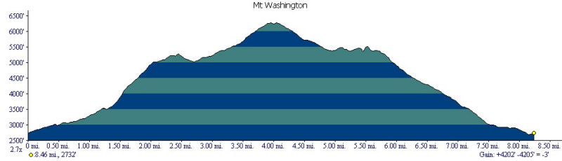
Stats
Mountains: Mts. Montroe (5,384) and Washington (6,288)
Date: September 30, 2006
Time: 10 hours
Weather: Mostly sunny, temps ranging in 30's and 40's
Miles: 13.21
Elevation Gain: +4,202
Steps: 42,721
Trails: Ammonoosuc Ravine Trail - Crawford Path - Great Gulf Trail - Gulfside Trail - Clay Loop - Jewell Trail
Holy Shit Factor: High, very high - that one place could hold so much
Picture Gallery
Short Video Clips
Cog Railway from Observation Desk on top of Mt Washington
View from atop Mt Monroe
OK, so waking up at 4:20 a.m. on the last day of September 2006 really sucks. It is dark and cold and too early to eat, but not too early for a big mug of French Roast. I like it strong, slightly sweet and slightly light. It is Nancy's turn to drive and we are on the road by 5 a.m. Dejah, our honorary trail dog, comes too. She doesn't care that it is early - she is more than ready. We stop at Mickey D's in Hillsborough for a drive-through breakfast - I get my hash browns this time but Nancy doesn't get any egg on her Egg McMuffin. Blah. As has become routine this hiking season, the drive up to Route 302 goes quickly - we talk and enjoy the views.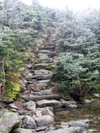
As we approach the trailhead we see that most of the Presidentials are still under cloud cover. In fact, in all our drives up to Rte. 302 we haven't seen the peaks of any Presidential summits - they are always obscured by clouds. I have checked and checked and checked the weather, and yes, I know any forecast is a crap shoot, but we decide that unlike the forecast last Tuesday, we have a good shot at seeing the top of Washington in clear skies. So we decide to go for it.
We start up the Ammonoosuc Ravine Trail at 8:30 a.m. The skies at the trailhead are clear and the temps are in the upper 30's to start. It is brisk but we soon warm up and begin the ritual of managing temperature as we climb and the day warms. Lots of folks in the parking lot heading up and we join the steady tramp of hikers. Maybe I'm a snoot, but I really don't enjoy being within sight or sound of other hikers and we spend the climb passing or being passed. Folks are friendly; that isn't the point - it is something else - just the presence of others on this special day. It is hard to think of being in the wilderness when there are so many people there and the sound of the trains slugging up the cog railway don't add much to the sense of wilderness either.
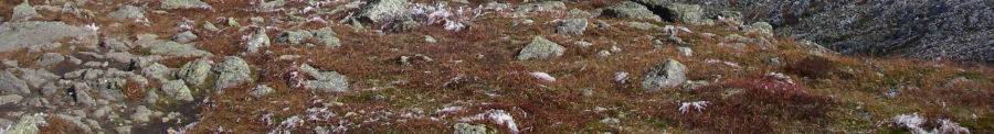
When we start to leave the tree line behind the views of the Washington Valley behind us and the rime ice on the ridge above us are awe inspiring. Everything is coated in a layer of frost, forced into position by the wind that tried to blow it off the branches the night before. The ravine offers a few challenging scrambles but mostly it is the views up, down and around that made my heart sing. A hiker comes down the trail and tells us that the ice is very treacherous from the Lakes of the Clouds Hut to the summit of Washington. I look around me and the sun is warm and with each passing minute more of the clouds above us scud away. I feel certain that it will melt by the time we get there. A young Park Ranger says that the forecast is for the summit to be stuck in clouds all day, but I also feel that the sun is going to win the day.
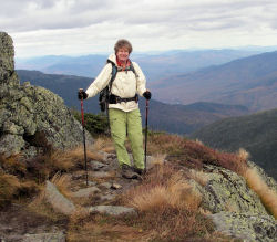
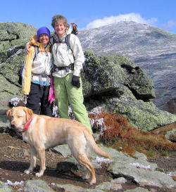 As we climb up to the junction of the Lakes of the Clouds Hut at 11:16 a.m. it is decision time - shall we detour and bag Monroe and then head to the Washington summit or just head to Washington now? It is an easy decision - of course we decide to go for it. We put on wind jackets and start up the Crawford Path before veering off on the Monroe Loop. Just as we reach the summit of Monroe - no summit sign - I turn around and the Washington summit stands there in all her frosted glory. It is spectacular and we take pictures and stare, wondering if this will be our only view for the day and vowing to take advantage of it. We hit the summit of Monroe (elevation 5,372) at 11:40 a.m. It is cold and blowing a bit, so we take pictures, slap a high five at #32 and start back down to the Hut. As we climb up to the junction of the Lakes of the Clouds Hut at 11:16 a.m. it is decision time - shall we detour and bag Monroe and then head to the Washington summit or just head to Washington now? It is an easy decision - of course we decide to go for it. We put on wind jackets and start up the Crawford Path before veering off on the Monroe Loop. Just as we reach the summit of Monroe - no summit sign - I turn around and the Washington summit stands there in all her frosted glory. It is spectacular and we take pictures and stare, wondering if this will be our only view for the day and vowing to take advantage of it. We hit the summit of Monroe (elevation 5,372) at 11:40 a.m. It is cold and blowing a bit, so we take pictures, slap a high five at #32 and start back down to the Hut.
Lots of people at the Hut eating lunch - the Hut itself is closed, but behind it people sit in the sun and eat. We pass on by having just snacked on a couple of power bars and start up the Crawford Path toward the summit of Washington. The ice isn't bad except in the shade and neither of us slip. The line of hikers twisting up the side of the ridge is incongruous and not particularly welcome - I've gotten spoiled hiking with my partner in relative silence - just natural sounds around us. The procession toward the summit that we are witnessing is, well, different. We join in and try to maintain space between ourselves and those behind and ahead. As we climb the ice becomes thicker and it is more difficult to see where the trail is since the trail consists of granite rocks with no sense of demarcation. All the buildings are covered with rime ice. I have seen pictures of this phenomenon, but never in person. We arrive at the summit of Washington (elevation 6,288) at 1:15 p.m. 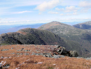
The summit is crowded with people who arrived on shuttles, cars and the railway. The views are incredible. I have not seen the northern Presidentials before and look on them with a kind of drooling awe. I, too, will someday stand on top of those mountains. We tie Dejah and go into the snack bar to warm up and use the facilities. Ten minutes later the speaker system crackles to life and we are told that anyone who left a yellow dog tied up outside had better get back out there - no unattended dogs. Dang - so much for getting warm. Dejah is being a good sport - not barking or anxious - so while Nancy goes back in to change from wet to dry clothes I stay outside with Dejah and start eating lunch. She joins me shortly thereafter, but despite no wind and plenty of sun, it is cold and just sitting is sapping our core warmth. We pack up and head for the Great Gulf Trail, but something about Nancy causes me to turn around and really look at her. She looks really cold so I suggest she head back inside and get warm before we start out. That proves to be a good decision - she is deeply cold. Dejah and I walk to the observation deck and watch the trains and take a movie of the view before heading back to meet Nancy.
 We end up in a large group of hikers heading down the Great Gulf Trail, then picking up the Gulfside Trail. We do what we can to put distance between us but that's hard on rocks covered with rime ice. As we approach the railway, I am surprised by the amount of cinder pollution created by the trains - the delicate alpine vegetation is clearly suffering from the continued use of coal burning train engines. Lots of hikers are heading up and lots are heading down - a looping caravan of people winding up and down the side of the mountain. When we get to the Clay Loop Trail we decide to go for it and bag Clay as well. At the time we were motivated by the fact that Clay would be our 34th summit - we didn't realize that Clay didn't "count" as a 4,000 footer despite its 5,553 elevation. And as we walk it is deceptive - with no summit sign which of the three bumps in the ridge is the summit? They all look like the height of land to us. After studying the map...again...we decide it is the furthest bump and make our way to the top at 3:25 p.m. We both still feel really strong and are flying high on the beauty surrounding us. We end up in a large group of hikers heading down the Great Gulf Trail, then picking up the Gulfside Trail. We do what we can to put distance between us but that's hard on rocks covered with rime ice. As we approach the railway, I am surprised by the amount of cinder pollution created by the trains - the delicate alpine vegetation is clearly suffering from the continued use of coal burning train engines. Lots of hikers are heading up and lots are heading down - a looping caravan of people winding up and down the side of the mountain. When we get to the Clay Loop Trail we decide to go for it and bag Clay as well. At the time we were motivated by the fact that Clay would be our 34th summit - we didn't realize that Clay didn't "count" as a 4,000 footer despite its 5,553 elevation. And as we walk it is deceptive - with no summit sign which of the three bumps in the ridge is the summit? They all look like the height of land to us. After studying the map...again...we decide it is the furthest bump and make our way to the top at 3:25 p.m. We both still feel really strong and are flying high on the beauty surrounding us.
We cut over to the Gulf Side Trail (for shame) which cut a half a mile off our descent. I know the 3.7 mile Jewell Trail is going to be a long one for me, and I can already feel some foot discomfort. I don't know how or when it happened, but I have a bruise on my right ankle bone and every step is painful as the bone touches the inside of my boot. I spend a lot of energy ignoring the pain. The Jewell Trail is a nice trail, fairly gentle, but as we descend into the trees, my feet become more and more tired and sore. It is an effort to maintain a decent pace. I think we are walking right along, but at least three other groups of hikers pass us on the way down. I guess we are just slow, and my knees don't add any speed to the journey. Nevertheless, we make it and the last mile is a fast one. The parking lot looks wonderful to me as we come out of the woods at 6:30 p.m. with just enough light left not to need our headlamps.
Dry clothes raise our spirits, although they are already pretty high. And we settle in for the long drive home. Sliding between the sheets at 11 p.m. is bliss. Pure unadulterated bliss.
What an incredible day! The weather, the lack of wind, no injuries, three peaks (two that counted), and we climbed Washington...at last.
31 of NH 48
33 of 67 in NE
34 of the NE 100 Highest
|