Peak Above the Nubble
Submitted by Pat
Stats
Mountain: Peak Above the Nubble (3,813)
Date: June 14, 2012
Time: 7 hours
Weather: Sunny, 70's, not a cloud in the sky
Miles: 6
Elevation Gain: 2,013
Trail: bushwhack
 As I sit here on a gorgeous, sunny summer day thinking about what to write about yesterday's bushwhack to Peak Above the Nubble, I have about four story lines buzzing in my head. I might as well get started. As I sit here on a gorgeous, sunny summer day thinking about what to write about yesterday's bushwhack to Peak Above the Nubble, I have about four story lines buzzing in my head. I might as well get started.
Nancy and I stopped working toward climbing the Hundred Highest mountains in NE after our experience on Vose Spur, after finishing the 67 4,000 Footers in NE, and going through numerous personal and professional changes. Last fall, I got the bug again and decided that I wanted to reclaim the goal of climbing the 100 Highest in NE. I only had 12 left and they were all bushwhacks. So I took a Map and Compass course and found some folks willing to hike with me. I climbed Peak Above the Nubble last September with Eileen and Bernie and then climbed Scar Ridge with them in October. I climbed both of these peaks without my hiking partner, Nancy, and I missed her. I knew she didn't like bushwhacking and if she found her way back to the goal of climbing the 100 Highest she would find her way back on her own terms.
I kept talking to her about my experiences and suddenly we found ourselves with an opportunity to climb Vose Spur with Eileen and Bernie and Nancy said she would give it a go. No promises of more, but willing to give this one a try. It would feel awfully good to get to the summit of this mountain that had caused us such vexation during our aborted attempt in 2008.
We did make it to the top of Vose Spur that day and Nancy came down the mountain and decided she was ready to finish the 100 Highest - that she will never like bushwhacking - but was willing to tackle the 11 of them that stand in the way of her getting her patch. Woo Hoo! I was pumped, psyched to get back into the woods and sharing a goal with my hiking partner. As is her wonderful style, she wanted to schedule the hikes immediately and get as many done as soon as possible. I offered to take her up Peak Above the Nubble and Scar Ridge, bushwhacks I had done with Eileen and Bernie, so Nancy could check them off as well.
Thursday, June 14 is the day scheduled for the two of us to climb Peak Above the Nubble. I meet her at her new condo (she had recently moved from her home of 23 years) and we give each other the look that means I didn't sleep well and what the hell am I doing up this early in the morning? We put her stuff in my car and head north. It's Bike Week in NH and the Tilt'n Diner is starting to get ready for the onslaught of bikers, but it's early enough to find a seat and eat a quick breakfast before continuing our trip to the White Mountains.
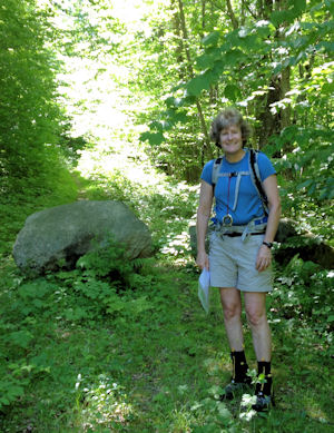
We find the trailhead parking - Forest Road 304A - where there are three boulders blocking the trail from motorized vehicles. We gear up - long sleeve shirt off, bug spray on, boots on, lunch packed, maps and GPS in my pocket, compass hanging off a pack strap, and unzip my pants to shorts. It's a beautiful day, sunny, not a cloud in the sky, cool, but not cold, with a slight breeze. I mark a waypoint on my GPS where the car is so we can get back. We look at the maps and try and set a bearing on our compasses, but neither of our efforts agrees so we decide to compromise and set the bearing for 210 that someone had mentioned in their report of hiking of this peak.
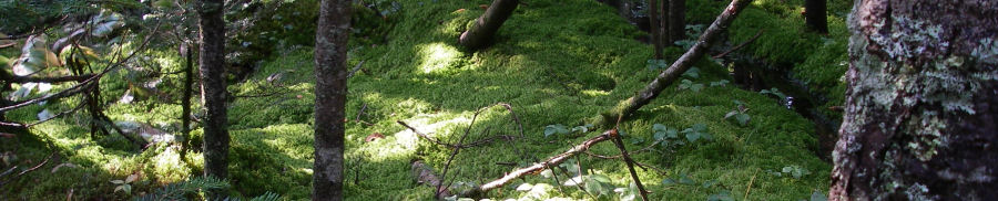
 As we walk up the path on the old woods road, the greenery surrounding us is lush and in full vigor of growth. Tiny toads and big fat toads jump off the trail as we approach. I don't want to step on anyone so I keep a sharp eye out. Nancy is reading some trail beta, information written by someone describing the first turns and landmarks before this bushwhack starts in earnest. I've been here before and remember the sand hill but my memory of distances, like how far we walk on the trail before turning right onto the logging road, is shaky. We stop to read and re-read the information again and again until we find the turn. I mark another waypoint and we head into the woods. As we walk up the path on the old woods road, the greenery surrounding us is lush and in full vigor of growth. Tiny toads and big fat toads jump off the trail as we approach. I don't want to step on anyone so I keep a sharp eye out. Nancy is reading some trail beta, information written by someone describing the first turns and landmarks before this bushwhack starts in earnest. I've been here before and remember the sand hill but my memory of distances, like how far we walk on the trail before turning right onto the logging road, is shaky. We stop to read and re-read the information again and again until we find the turn. I mark another waypoint and we head into the woods.
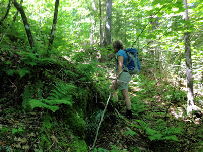
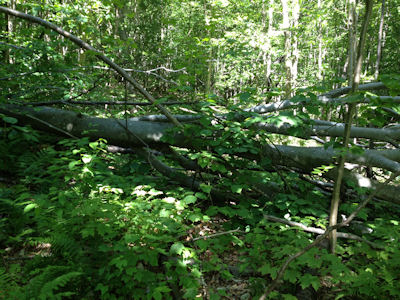
I had bought a new GPS the day before, loaded maps, and did a crash course in learning how to make it a useful tool on this hike. My new Garmin eTrex 30 is safely in my pocket and I hope I know enough that I can read it and use it today. We start up toward the ridge shortly after we enter the woods. Everything looks green, with some dead trees scattered under the leaf canopy, and lots of blowdowns, the ground moist and soft and wet. I leave the GPS in my pocket and we start up the ridge using only the compass to guide our direction of travel. The going is pretty easy down at 1800 feet, but we soon meet up with a series of rock ledges that we have to navigate through or around.
This craziness lasts for a long time. As soon as we get around a ledge there are three more in front of us. We have to watch every step we take. Boot sucking holes hidden between roots and rocks by a layer of moss and leaves lie in wait for the unaware hiker. Dead branches slap, poke, stab, and crumble beneath our boots. Nancy is leading and is doing a great job following the compass heading, maneuvering us around and over blow downs and ledges. It's hard work. I have to constantly focus on the compass bearing, where I put my feet, where my partner is, and the contours and lay of the land. Bushwhacking is challenging mentally, physically, and emotionally. It requires that I stay focused all the time.
I have to admit that we find some surveyor's tape marking some of the trail through and around the ledges. Those little orange ribbons that got us into so much trouble when we admitted to using them on the hiking forum when we aborted our bushwhack on Vose Spur feel like the balm of confidence now. I feel the peace and safety as we follow them. We lose them after a while and are again on our own. I'm leading when we come to the base of a huge rock cliff. It looms into the sky for hundreds of feet straight up. Definitely time to go around. But which way? Right? Left? Both choices look awful but in the end I choose left. It takes us a while, with several starts and stops to find the best way, before we finally leave the ledges behind and work our way through a mix of birch and spruce to the ridge.
Nancy and I are talking, sharing ideas about which way to go, staying connected mentally, physically and emotionally. I drift in and out of my comfort zone as we walk. I felt strong following the orange tape and now we're on our own again. Everything looks good, compass bearing and GPS. I guess we have just chosen a difficult track. No way to know until you start hiking. I know we are on the ridge because I can see blue sky through the trees to my right and my left. There we are, two hours into the hike, and nowhere to go but forward. So forward we go, straight into spruce hell. Thick groves of spruce with dead branches below their green head of needle hair, pushing through them by force, trying to hold back the branches, trying to see the best way, the easiest way, over blow downs and around and through.
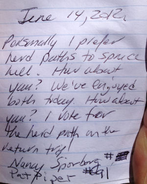
 Blood is drawn - a branch punctures Nancy's bicep. It's not bad but it's bleeding pretty well. I clean it up as best I can with my bandana assuring her that we'll do a better job when we get to the summit. Shortly after that I ram a shin into the exposed end of an unseen branch and my blood is drawn. There. It's done. Blood is spilled. Onward. Struggling through the spruce I look to my left and a memory of the time I climbed this mountain with Eileen and Bernie comes to me and I stop, ask Nancy to hang there while I explore to the left, and sure enough it's the herd path! Almost the same exact place I found it the last time. Big smiles appear on our faces. I know where I am. The herd path is relatively easy to follow and we are close to the summit. It is 1:30 in the afternoon. I revel in the feeling of safety and swallow whole the comfort I feel. Wow, this is hard stuff… bushwhacking. Nancy and I against the woods of northern New Hampshire. Find your way or die. Powerful, emotional stuff. Blood is drawn - a branch punctures Nancy's bicep. It's not bad but it's bleeding pretty well. I clean it up as best I can with my bandana assuring her that we'll do a better job when we get to the summit. Shortly after that I ram a shin into the exposed end of an unseen branch and my blood is drawn. There. It's done. Blood is spilled. Onward. Struggling through the spruce I look to my left and a memory of the time I climbed this mountain with Eileen and Bernie comes to me and I stop, ask Nancy to hang there while I explore to the left, and sure enough it's the herd path! Almost the same exact place I found it the last time. Big smiles appear on our faces. I know where I am. The herd path is relatively easy to follow and we are close to the summit. It is 1:30 in the afternoon. I revel in the feeling of safety and swallow whole the comfort I feel. Wow, this is hard stuff… bushwhacking. Nancy and I against the woods of northern New Hampshire. Find your way or die. Powerful, emotional stuff.
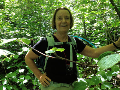
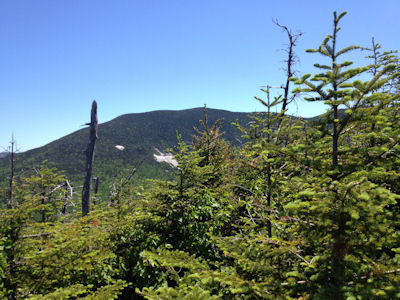
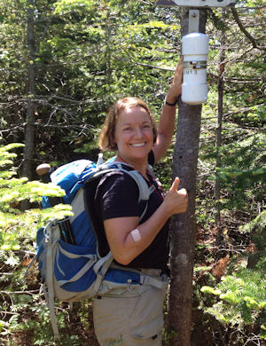
I feel hugely alive as I stride to the clearing below the summit canister. Nancy takes a picture as I lift the top off the canister and pull out the baggie containing the summit log. It's 2 o'clock and we made it. We made it to the top, just the two of us, intact, still smiling, and very proud. We walk to the lookout and gaze out toward Mt. Washington. The day is perfect, the sky cloudless, and the bugs aren't driving us mad. We sit, eat lunch, and read the entries in the summit log. I show her the one Bernie, Eileen and I wrote last October. I miss you, Nancy was the last line of the entry. I smile at my friend, hardly believing that we made it up here, a place I didn't think we would ever stand together, and here we are.
After lunch and some medical treatment, we pack up and head back down the herd path. I am leading, feeling pretty confident I can follow the path back to the spot where we need to head down the ridge and start bushwhacking again. I am looking for areas that I remember coming up - a log that looked a certain way, a turn in the trail, a boot print - and I see a few familiar things. Each time I see something I remember I sigh gratefully and know we are still on the right track. Maybe ten minutes into the walk I start thinking I haven't been here before. Nancy speaks up and says This doesn't look right. A few turns later, I agree - we go back, looking for the right trail. We find it where some blowdowns had disguised the path. Phew. Back on the trail.
I am still in the lead when we come to the spot where the herd path intersects with an "illegal" path cut by someone and frowned upon for the lack of attention to issues around soil erosion. Some controversy about who has the right to say that a path is illegal, but it's true - this path was cut by someone, is badly eroded, and is no longer a bushwhack. Close by is the herd path I remember taking down when I hiked with Eileen and Bernie so we start down. It's hard to follow and for some reason I remember being able to stay on it for much longer on my first hike than I do today. Fifteen minutes into our descent I lose the path. I had told Nancy we would be on it longer and our sense of safety and good humor seep out into the air as we look at each other and decide what to do next.
I don't want to go down the way we came up - I want to avoid those ledges. Nancy agrees, but we are at odds. Basically we are giving up the compass bearing that was successful in getting us to the top and trusting that my instinct, the condition of our unknown and newly chosen path, and the tracks the GPS will get us to safety. It's a hard moment, but we make the decision and bear right down the side of the ridge toward the woods road path we came in on. The going is tough with areas of thick spruce (though not as many or as bad as what we encountered on the way up), steep rock ledges we slide down on our butts, our boots sliding through the moss and holding on to trees that occasionally break off or tumble over. We need constant attention to where we put our feet and hands.
 We finally get down past the ledges and spruce and enter a different kind of hell - hobblebushes. These low lying, viney shrubs are aptly named. I can't see my feet for their leaves and their branches are a tangled maze of strong, thin wood, holding me back, tripping me up, winding around me. But we continue to push through until we reach a clearing - must have been an old logging area - no trees but plenty of hobblebush, spiny blackberry bushes, and other unidentified vegetation that covers the view of our footing and scrapes at arms and legs. We finally get down past the ledges and spruce and enter a different kind of hell - hobblebushes. These low lying, viney shrubs are aptly named. I can't see my feet for their leaves and their branches are a tangled maze of strong, thin wood, holding me back, tripping me up, winding around me. But we continue to push through until we reach a clearing - must have been an old logging area - no trees but plenty of hobblebush, spiny blackberry bushes, and other unidentified vegetation that covers the view of our footing and scrapes at arms and legs.
It's hard to hold onto confidence when I'm working so hard just to push my body down the side of a hill where the flora is conspiring to stop me. The GPS shows slow progress. It looks like we are hardly moving and I wonder if the GPS has stopped working. If it has and we've lost our compass bearing I know that if we keep heading northwest we will meet up with the path on the woods road, but let me tell you it's hard to hold onto that confidence when I have such limited experience. I still feel I will get us out - it's strong in my gut - it's a small fire, but it is a fire and I fan the flames when I feel myself losing trust. We are both out of our comfort zones. It's scary to be out in the middle of nowhere, having to depend on our own skills and experience to get us back to the car. It's enough to make us lose trust in ourselves and each other, but I say I promise I will get us out of here, Nancy, and I believe it.
We follow a drainage for a good portion of the way down the ridge. I know it will lead us to the bottom, to the path, and to safety. I feel good and I need all the confidence I can muster. So we push and push and push through the thick vegetation until finally I look through and see what looks like a path. Yes! It's the path! We did it! We are out of the hell and onto safe ground. God, it feels good. We grin at each other, high five, but don't have a lot of energy to celebrate otherwise. We begin a silent walk back to the car. We are silent because what is there to say? We are tired, bruised, scratched, and wondering what the hell we are doing going through this in order to know that we have climbed the 100 highest mountains in New England.
We begin the drive home in relative silence. Nancy is sitting with her thoughts, letting the tension ease out of her body, letting the feeling of safety soothe her exhaustion. Halfway home we have an incredible conversation - we have put enough distance between the experience and our present moment that we are actually discussing our next bushwhack, how the bushwhacks in Maine have herd paths and aren't as hard. How quickly we put distance between a difficult experience and the desire to meet a goal.
We did it - together - we bushwhacked to the summit of Peak Above the Nubble, just the two of us. That is something I didn't think we would ever do. I thought I would finish the 100 highest on my own. And here we are back on the journey, together. Woo Hoo!
90 out of 100 Highest
|